1972
2007

| Home | Trip Report 2011 | Contact |
28-Aug-2013
This section examines the changes in travel and technology between 1972 and 2011.
1972 |
2007 |
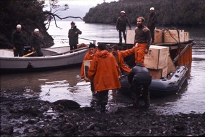
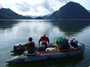
| The 1972/72 expedition was transported to Kelly Inlet by Chilean Navy Ship Aquilla from Puerto Montt. | In 2007, the converted fishing vessel Huemules transported the team from Puerto Yungay. |
|
|
| Off loading to Base Camp on the north side of Kelly Inlet. | Off loading to a Base Camp near 'Isla' Boscosa on the Eastern shore of Kelly Inlet. |
|
|
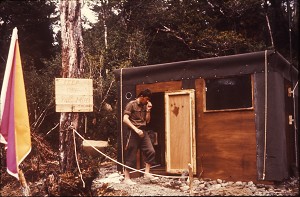
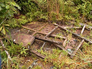
| A hut was constructed at the 1972 Base Camp. | All that remained of the hut 35 years later. |
|
|
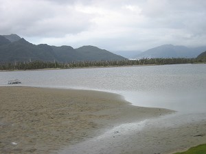
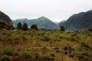
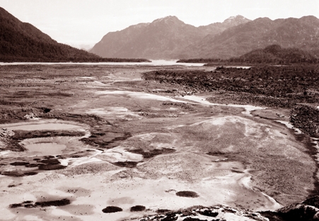
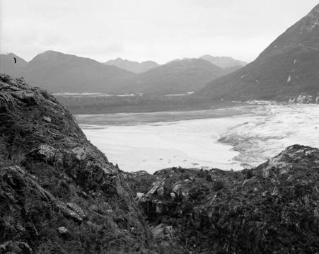
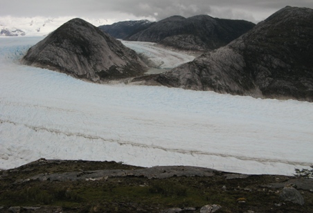
| At the Eastern end of Kelly Inlet looking towards the Andree glacier valley. | At the Eastern end of Kelly Inlet looking towards Glacier Benito. |
|
|
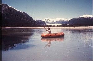
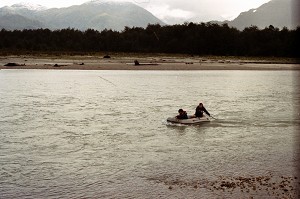
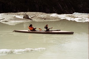
| Crossing the Andree River. Crispin swam across the river in 1973. | Endeavouring to cross the Andree River at a similar position. The river width appeared less but the flow was faster. |
|
|
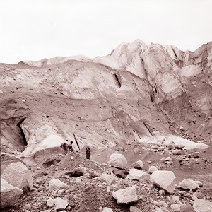
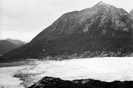
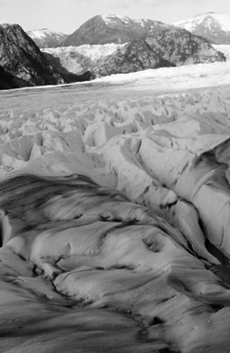
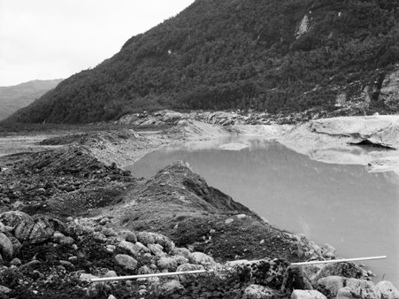
| At the 'snout' of Glacier Benito. | The same site in 2007. The aluminium pole was still sticking in the ground to mark the site. |
|
|
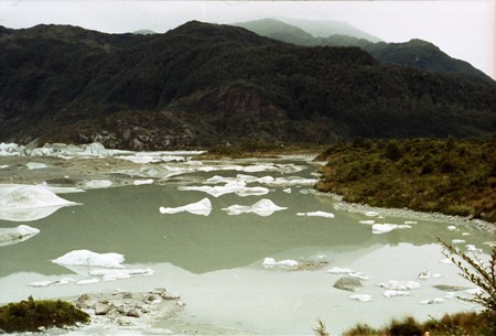
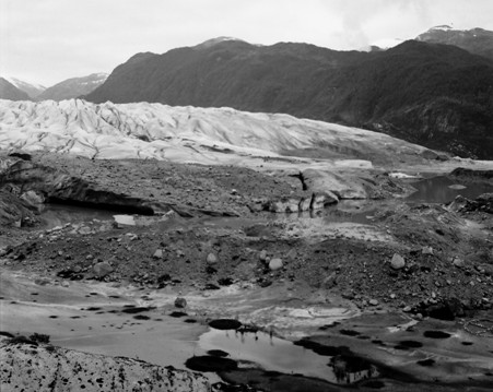
| We were able to access the glacier directly from the moraine near the 'snout' camp over an ice bridge under which a river flowed. | This time we had to canoe to the southern side of the glacier to find a suitable ice bridge onto the glacier. |
|
|
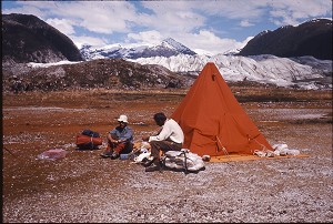
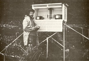
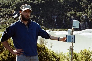
| This was our meteorological station in 1972/73 in Kelly Inlet. | This little meteorological station could record for longer periods and more parameters too, especially logging wind speed and direction as well as rainfall hour by hour. |
This section examines the changes in Glacier Benito between 1972 and 2007.
1972 |
2007 |
 |
 |
| The ice bridge onto the glacier. | Same view in 2007. |
 |
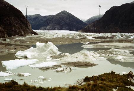 |
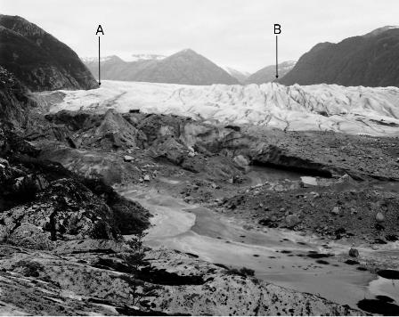
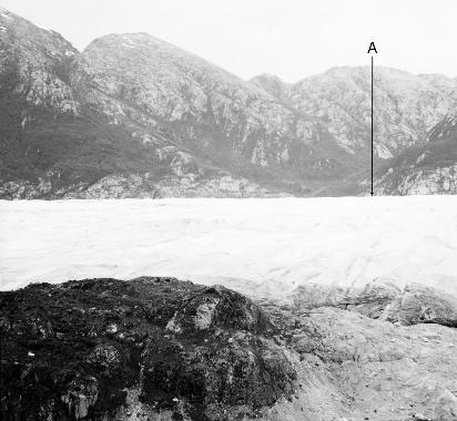
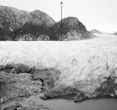
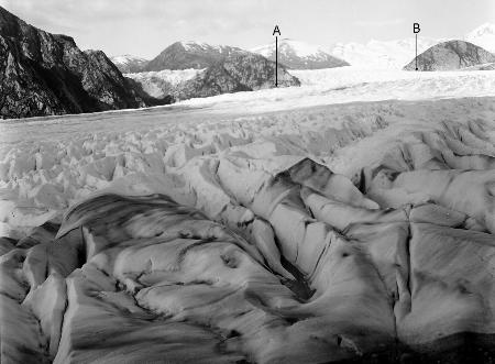
| Looking up the glacier from the new moraine in 1972. | Arrow A is a reference point to enable the two photographs to be compared. |
 |
|
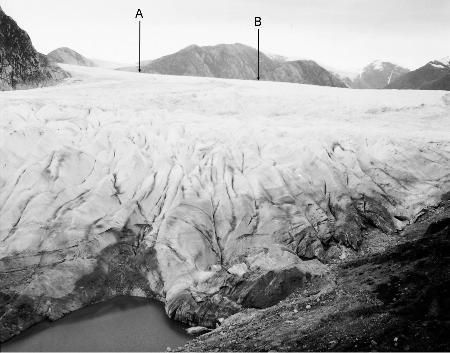
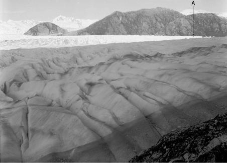
| The North side of the glacier. | Same view in 2007. Arrow B is a reference point to enable the two photographs to be compared. |
 |
.jpg) |
| These six sets of photographs show the glacier from Camp cairn in 1972/73 starting from the north side of the glacier. | The same views in 2007. |
 |
.jpg) |
| Camp cairn comparison 2 looking directly up glacier. The arrows A and B mark where the glacier surface appears on the valley sides in 1972. | In the distance (about 2.5 km up glacier), the glacier surface has dropped 140 m since 1973 (at an average rate of 4 metres a year - the height of a single story house). |
 |
.jpg) |
| Camp cairn comparison 3 showing the terminal moraines. | |
 |
.jpg) |
| Camp cairn comparison 4. | |
 |
.jpg) |
| Camp cairn comparison 5. In the distance is the pronounced gap in the Little Ice Age (LIA) moraine where the outlet river flows to the Benito Fjord. | |
 |
|
| Camp cairn comparison 6. Looking towards Benito fjord in the South West. Note how scarce the vegetation is. | Very much more vegetated in 2007. |
 |
.jpg) |
| Glacier photographed from White Boulder 'trig' point. Seven sets of photographs to illustrate the changes. Note how wide the braided stream zone appears. | The shape of the moraine is similar to the glacier terminus in 1973. |
 |
.jpg) |
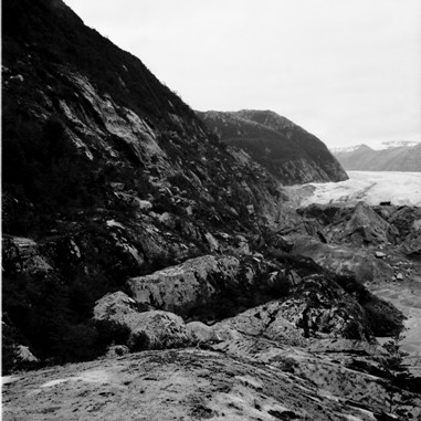
| White Boulder comparison 2. Note the bare rock below the tree line on the North side of the valley. The base of the tree line is about 85 m above the glacier. | |
|
.jpg) |
| White Boulder comparison 3. | |
 |
.jpg) |
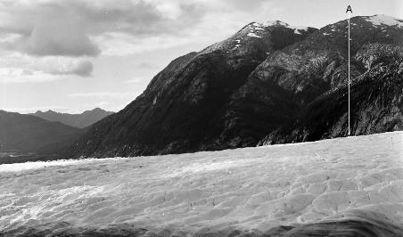
| White Boulder comparison 4. | The arrow A marks where the glacier surface appears on the North valley side in 1972. |
 |
.jpg) |
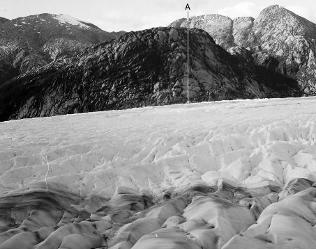
| White Boulder comparison 5. | The arrow A marks where the glacier surface appears on the North valley side in 1972. In the foreground the glacier would have covered the dark vegetation in 1972. |
 |
.jpg) |
| White Boulder comparison 6. | The arrows A and B mark where the glacier surface appears on the valley side in 1972. |
 |
.jpg) |
| White Boulder pair 7. Looking towards the next survey 'trig' point at Cairn. | The water level at the edge of the glacier is the same as the outlet river for 'Lago' Benito. The arrow A marks where the glacier surface appears on the South valley side in 1972. |
 |
.JPG) |
| A series of 7 pairs of photographs taken at Cairn. In the distance is Kelly Inlet. Only a small part of River Benito outwash plain can be seen above the glacier. | Much more of River Benito can be seen because it is not hidden by the glacier. |
 |
.JPG) |
| Cairn comparison 2. | The arrow A marks where the glacier surface appears on the North valley side in 1972. |
 |
.JPG) |
| Cairn comparison 3. | The arrow A marks where the glacier surface appears on the North valley side in 1972. |
 |
.JPG) |
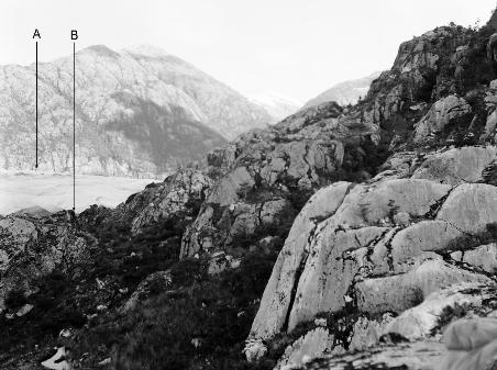
| Cairn comparison 4. | The arrows A and B mark where the glacier surface appears on the valley sides in 1972. |
 |
.JPG) |
| Cairn comparison 5. | The arrow A marks where the glacier surface appears on the valley sides in 1972. |
 |
|
| Cairn comparison 6. | The arrow A marks where the glacier surface appears on the valley sides in 1972. |
 |
.JPG) |
| Cairn comparison 7. To the right of Arrow A are two valleys that contained large glacier dammed lakes. | The arrow A marks where the glacier surface appears on the South valley side in 1972. The arrow B marks the same foreground point in both photographs. These lakes have almost disappeared by 2007 and are no longer dammed by the glacier. |
 |
 |
| This is an extract from Cairn pair 4 above and shows a valley that we walked up in 2007 and 2011. The ridge at the top was probably under many meters of ice in this photograph. | The valley was well vegetated all the way up in 2007. |
 |
.JPG) |
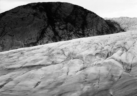
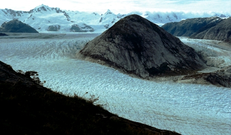
| This series looks at another feature which in 1972 was called the 'Island' as it was totally surrounded by ice. Because the side tongue of the glacier was relatively stagnant, we were able to walk up it relatively easily. | By 2007, the tongue has receded so far that a small lake was contained between the ridge and the former 'Island'. |
 |
.JPG) |
| In this photograph, the top edge is visible. | |
 |
 |
| In this photograph, the bottom edge of the former 'Island' is visible. | |
 |
 |
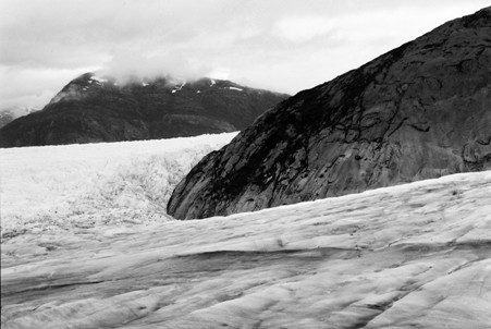
| This shows the crossing point from the main glacier to the side tongue around the west side of the former 'Island'. The contrast in the two ice types is evident. | |
 |
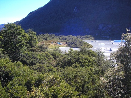 |
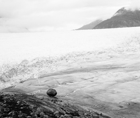
| In 1973, a second aluminium pole was left on top of the 'new' moraine near the main outlet river. In the distance is the ice bridge used to access the glacier. | This pole was found again in 2007. The photograph show how vegetation has grown since 1972. |
|
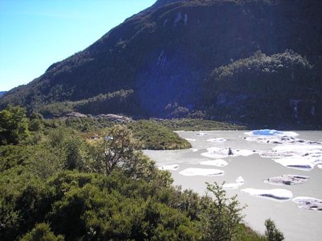 |
| - | A slightly different vantage point to show more of the lake. |